Atlas of Prince Eugene
 – 389030-F.K 1-46, I-IV – Österreichische Nationalbibliothek (Vienna, Austria)")
Amsterdam (Netherlands) — 1662–1678
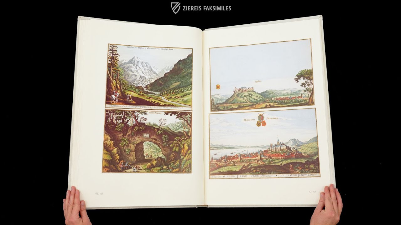
Switzerland in the 17th century with modern-looking urban panoramas: accurate maps and detailed cityscapes from the estate of the influential Prince Eugene of Savoy
This coveted collection of cityscapes and maps is named after its later owner Prince Eugene of Savoy (1663–1736)
Individual regions of Switzerland are depicted in one of the most sought-after works of the 17th century
The artistic adornment includes masterful details like waterfalls, rocky gorges, and dwellings
Atlas of Prince Eugene

 – 389030-F.K 1-46, I-IV – Österreichische Nationalbibliothek (Vienna, Austria)")
 – 389030-F.K 1-46, I-IV – Österreichische Nationalbibliothek (Vienna, Austria)")
 – 389030-F.K 1-46, I-IV – Österreichische Nationalbibliothek (Vienna, Austria)")
 – 389030-F.K 1-46, I-IV – Österreichische Nationalbibliothek (Vienna, Austria)")
 – 389030-F.K 1-46, I-IV – Österreichische Nationalbibliothek (Vienna, Austria)")
 – 389030-F.K 1-46, I-IV – Österreichische Nationalbibliothek (Vienna, Austria)")
 – 389030-F.K 1-46, I-IV – Österreichische Nationalbibliothek (Vienna, Austria)")
 – 389030-F.K 1-46, I-IV – Österreichische Nationalbibliothek (Vienna, Austria)")
 – 389030-F.K 1-46, I-IV – Österreichische Nationalbibliothek (Vienna, Austria)")
 – 389030-F.K 1-46, I-IV – Österreichische Nationalbibliothek (Vienna, Austria)")
 – 389030-F.K 1-46, I-IV – Österreichische Nationalbibliothek (Vienna, Austria)")
 – 389030-F.K 1-46, I-IV – Österreichische Nationalbibliothek (Vienna, Austria)")
 – 389030-F.K 1-46, I-IV – Österreichische Nationalbibliothek (Vienna, Austria)")
 – 389030-F.K 1-46, I-IV – Österreichische Nationalbibliothek (Vienna, Austria)")
 – 389030-F.K 1-46, I-IV – Österreichische Nationalbibliothek (Vienna, Austria)")
 – 389030-F.K 1-46, I-IV – Österreichische Nationalbibliothek (Vienna, Austria)")
 – 389030-F.K 1-46, I-IV – Österreichische Nationalbibliothek (Vienna, Austria)")
 – 389030-F.K 1-46, I-IV – Österreichische Nationalbibliothek (Vienna, Austria)")
 – 389030-F.K 1-46, I-IV – Österreichische Nationalbibliothek (Vienna, Austria)")
 – 389030-F.K 1-46, I-IV – Österreichische Nationalbibliothek (Vienna, Austria)")
 – 389030-F.K 1-46, I-IV – Österreichische Nationalbibliothek (Vienna, Austria)")
 – 389030-F.K 1-46, I-IV – Österreichische Nationalbibliothek (Vienna, Austria)")
 – 389030-F.K 1-46, I-IV – Österreichische Nationalbibliothek (Vienna, Austria)")
 – 389030-F.K 1-46, I-IV – Österreichische Nationalbibliothek (Vienna, Austria)")
 – 389030-F.K 1-46, I-IV – Österreichische Nationalbibliothek (Vienna, Austria)")
 – 389030-F.K 1-46, I-IV – Österreichische Nationalbibliothek (Vienna, Austria)")
 – 389030-F.K 1-46, I-IV – Österreichische Nationalbibliothek (Vienna, Austria)")
 – 389030-F.K 1-46, I-IV – Österreichische Nationalbibliothek (Vienna, Austria)")
 – 389030-F.K 1-46, I-IV – Österreichische Nationalbibliothek (Vienna, Austria)")
 – 389030-F.K 1-46, I-IV – Österreichische Nationalbibliothek (Vienna, Austria)")
 – 389030-F.K 1-46, I-IV – Österreichische Nationalbibliothek (Vienna, Austria)")
 – 389030-F.K 1-46, I-IV – Österreichische Nationalbibliothek (Vienna, Austria)")
(1,000€ - 3,000€)
The volume at hand of the 50-volume Atlas of Prince Eugene concerns Switzerland and assembles gorgeous views of city- and landscapes as well as interesting cartographical depictions that give a marvelous glimpse of 17th century Switzerland! Laurens van der Hem compiled his famous atlas in the years 1662–1678. He collected and integrated sheets from outstanding artists of his time as well as older works. Roelandt Savery, Willem Schellinks, Jan Haeckert, Adriaen Matham and Frederic de Moucheron, Wenzel Hollar, Matthäus Merian, and Jacob Hoefnagel are only a few names of the famous people whose engravings were incorporated into the work.
Atlas of Prince Eugene
This treasure of the Austrian National Library is named after Prince Eugene of Savoy. The Austrian noblemen and general acquired the famous Atlas Blaeu – van der Hem, which had been in the possession of the Amsterdam patrician Laurens van der Hem, in the 18th century, and has been known as the Atlas of Prince Eugene ever since. The 50-volume atlas was compiled between 1662 and 1678 as a comprehensive geographical overview and subsequently came to be considered as an important attraction for the city of Amsterdam. Matthäus Merian was involved as a copper engraver, his etchings were colored by the “master colorist” Dirk Jansz van Santen. The volume at hand concerning Switzerland assembles gorgeous views of city- and landscapes as well as interesting cartographical depictions that give a marvelous glimpse of 17th century Switzerland!
Switzerland in Impressive Engravings
An impressive waterfall cascades amidst a rocky gorge and a few small houses. Lake Lucerne stretches out in the middle of a terrifically green landscape, and the backdrop of the city of Basel rises up majestically before the blue firmament. The Swiss volume of the famous Atlas Blaeu – van der Hem collects simultaneously gorgeous and informative maps and views. Individual regions of Switzerland are portrayed, as well as cityscapes or views of famous tourist attractions and depictions of natural spectacles.
The Treasure of an Amsterdam Patrician
This 17th century geographic treasure is stored today among the rich collections of the Austrian National Library. It is a famous atlas – a 50-volume collected work of old city- and landscapes – that was in the possession of the Amsterdam patrician Laurens van der Hem (1621–1678). This Atlas Blaeu – van der Hem was considered to be one of the symbols of the city of Amsterdam. Countless visitors came to wonder at it, the Medici among them, who would have gladly bought the compendium. Nonetheless, it remained in Amsterdam. In 1736, the work was finally sold to the Prince Eugene of Savoy (1663–1736) by the Van der Hem family. The compendium reached Vienna by courtesy of this famous patron of the arts and Hapsburg general in the Great Turkish War and the War of the Spanish Succession. The atlas, now named after Prince Eugene, was transferred by Emperor Charles VI to the court library, the modern Austrian National Library.
Matthäus Merian’s Image of Switzerland
Laurens van der Hem compiled his famous atlas in the years 1662–1678. He collected and integrated sheets from outstanding artists of his time as well as older works. Roelandt Savery, Willem Schellinks, Jan Haeckert, Adriaen Matham and Frederic de Moucheron, Wenzel Hollar, Matthäus Merian, and Jacob Hoefnagel are only a few names of the famous people whose engravings were incorporated into the work. The copperplates by Matthäus Merian the Younger (1621–1687) were of great significance for the Swiss volume. The marvelous views were colored by Dirck Jansz van Santen, who was already praised as a master colorist among his contemporaries. This volume concerning Switzerland comprises 35 views and eight maps with detailed geographic information. It gives, as such, a unique overview of 17th century Switzerland!
Codicology
- Alternative Titles
- Atlas des Prinzen Eugen
- Size / Format
- 50 volumes / 57.0 × 38.0 cm
- Origin
- Netherlands
- Date
- 1662–1678
- Epochs
- Style
- Genre
- Language
- Illustrations
- 35 views and 8 maps in original size of Atlas Blaeu - van der Hem from the Austrian National Library Vol. 1
- Artist / School
- Joan Blaeu (printer)
Matthäus Merian of Basel (engraver)
Dirck Jansz van Santen (illustrator) - Previous Owners
- Laurens van der Hem
Prince Eugen of Savoye
 – 389030-F.K 1-46, I-IV – Österreichische Nationalbibliothek (Vienna, Austria)")
Atlas of Prince Eugene
Pleasure Boating on Lake Zurich
In the lower-right corner of this cityscape we see various boats filled with people enjoying a pleasant day on Lake Zurich. It is a wonderfully detailed woodcut showing a literal boatload of musicians wearing Spanish collars in the foreground, including a cellist, and the city of Zurich in the background with its mixture of red tile and blue slate roofs. The Renaissance city’s defenses are depicted in a very realistic manner including a water gate, curtain wall, and various towers.
 – 389030-F.K 1-46, I-IV – Österreichische Nationalbibliothek (Vienna, Austria)")
Atlas of Prince Eugene
Cityscape of Geneva
The full Latin title translates to “The old and important city of Geneva naturally represented from the south with the surrounding landscape 1640” pretty much sums it up. It is a gorgeous panorama requiring a third page to fold out on the left. Sailing ships, medieval architecture, and the rolling landscape are depicted with great artistry and detail.
However, the tranquil appearance of the scene is quickly betrayed upon closer examination of the foreground – there is a battle at the city’s Renaissance fortifications. Phalanxes of pikemen, supported by arquebusiers, assault the city, which is defended by cannon fire. The flags of the assaulting troops, a white cross on a field of red, indicate that they are from the Duchy of Savoy, a bitter enemy of the Swiss at the time.
 – 389030-F.K 1-46, I-IV – Österreichische Nationalbibliothek (Vienna, Austria)")
#1 Atlas des Prinzen Eugen
Language: German
(1,000€ - 3,000€)
")
")
")
")
 – Belser Verlag – gr. 2\"@Kart. B 396 – Staatsbibliothek Berlin (Berlin, Germany)")
- Treatises / Secular Books
- Apocalypses / Beatus
- Astronomy / Astrology
- Bestiaries
- Bibles / Gospels
- Chronicles / History / Law
- Geography / Maps
- Saints' Lives
- Islam / Oriental
- Judaism / Hebrew
- Single Leaf Collections
- Leonardo da Vinci
- Literature / Poetry
- Liturgical Manuscripts
- Medicine / Botany / Alchemy
- Music
- Mythology / Prophecies
- Psalters
- Other Religious Books
- Games / Hunting
- Private Devotion Books
- Other Genres
- Afghanistan
- Armenia
- Austria
- Belgium
- Colombia
- Croatia
- Czech Republic
- Denmark
- Egypt
- Ethiopia
- France
- Germany
- Hungary
- India
- Iran
- Iraq
- Israel
- Italy
- Japan
- Luxembourg
- Mexico
- Morocco
- Netherlands
- Peru
- Poland
- Portugal
- Russia
- Serbia
- Spain
- Sri Lanka
- Sweden
- Switzerland
- Syria
- Turkey
- Ukraine
- United Kingdom
- United States
- Uzbekistan
- Aboca Museum
- Ajuntament de Valencia
- Akademie Verlag
- Akademische Druck- u. Verlagsanstalt (ADEVA)
- Aldo Ausilio Editore - Bottega d’Erasmo
- Alecto Historical Editions
- Alkuin Verlag
- Almqvist & Wiksell
- Amilcare Pizzi
- Andreas & Andreas Verlagsbuchhandlung
- Archa 90
- Archiv Verlag
- Archivi Edizioni
- Arnold Verlag
- ARS
- Ars Magna
- ArtCodex
- AyN Ediciones
- Azimuth Editions
- Badenia Verlag
- Bärenreiter-Verlag
- Belser Verlag
- Belser Verlag / WK Wertkontor
- Benziger Verlag
- Bernardinum Wydawnictwo
- BiblioGemma
- Biblioteca Apostolica Vaticana (Vaticanstadt, Vaticanstadt)
- Bibliotheca Palatina Faksimile Verlag
- Bibliotheca Rara
- Boydell & Brewer
- Bramante Edizioni
- Brepols Publishers
- British Library
- C. Weckesser
- Caixa Catalunya
- Canesi
- CAPSA, Ars Scriptoria
- Caratzas Brothers, Publishers
- Carus Verlag
- Circulo Cientifico
- Club Bibliófilo Versol
- Club du Livre
- CM Editores
- Collegium Graphicum
- Collezione Apocrifa Da Vinci
- Comissão Nacional para as Comemorações dos Descobrimentos Portugueses
- Coron Verlag
- Corvina
- CTHS
- D. S. Brewer
- De Agostini/UTET
- De Schutter
- Deuschle & Stemmle
- Deutscher Verlag für Kunstwissenschaft
- DIAMM
- Droz
- E. Schreiber Graphische Kunstanstalten
- Ediciones Boreal
- Ediciones Grial
- Ediclube
- Edições Inapa
- Edilan
- Editalia
- Edition Georg Popp
- Edition Leipzig
- Edition Libri Illustri
- Editiones Reales Sitios S. L.
- Éditions de l'Oiseau Lyre
- Editions Medicina Rara
- Editorial Casariego
- Editorial Mintzoa
- Editrice Antenore
- Editrice Velar
- Edizioni Edison
- Egeria, S.L.
- Eikon Editores
- Electa
- Enciclopèdia Catalana
- Eos-Verlag
- Ephesus Publishing
- Eugrammia Press
- Extraordinary Editions
- Fackelverlag
- Facsimila Art & Edition
- Facsimile Editions Ltd.
- Facsimilia Art & Edition Ebert KG
- Faksimile Verlag
- Feuermann Verlag
- Folger Shakespeare Library
- Franco Cosimo Panini Editore
- Friedrich Wittig Verlag
- Fundación Hullera Vasco-Leonesa
- G. Braziller
- Gabriele Mazzotta Editore
- Gebr. Mann Verlag
- Gesellschaft für graphische Industrie
- Getty Research Institute
- Giovanni Domenico de Rossi
- Giunti Editore
- Graffiti
- Grafica European Center of Fine Arts
- Guido Pressler
- Guillermo Blazquez
- H. N. Abrams
- Harrassowitz
- Helikon
- Hendrickson Publishers
- Henning Oppermann
- Herder Verlag
- Hes & De Graaf Publishers
- Hoepli
- Hortus Deliciarum
- Houghton Library
- Hugo Schmidt Verlag
- Idion Verlag
- Il Bulino, edizioni d'arte
- ILte
- Imago
- Insel Verlag
- Instituto de Estudios Altoaragoneses
- Instituto Nacional de Antropología e Historia
- Istituto dell'Enciclopedia Italiana - Treccani
- Istituto Ellenico di Studi Bizantini e Postbizantini
- Istituto Geografico De Agostini
- Istituto Poligrafico e Zecca dello Stato
- Italarte Art Establishments
- J. Thorbecke
- Jan Thorbecke Verlag
- Johnson Reprint Corporation
- Jugoslavija
- Karl W. Hiersemann
- Kasper Straube
- Kaydeda Ediciones
- Konrad Kölbl Verlag
- Kurt Wolff Verlag
- La Liberia dello Stato
- La Linea Editrice
- La Meta Editore
- Lambert Schneider
- Landeskreditbank Baden-Württemberg
- Leo S. Olschki
- Les Incunables
- Library of Congress
- Libreria Musicale Italiana
- Lichtdruck
- Lito Immagine Editore
- Lumen Artis
- Lund Humphries
- M. Moleiro Editor
- Maison des Sciences de l'homme et de la société de Poitiers
- Manuscriptum
- Maruzen-Yushodo Co. Ltd.
- MASA
- McGraw-Hill
- Militos
- Millennium Liber
- Müller & Schindler
- National Library of Wales
- Neri Pozza
- Nova Charta
- Oceanum Verlag
- Odeon
- Orbis Mediaevalis
- Orbis Pictus
- Österreichische Staatsdruckerei
- Oxford University Press
- Pageant Books
- Parzellers Buchverlag
- Patrimonio Ediciones
- Pattloch Verlag
- PIAF
- Pieper Verlag
- Plon-Nourrit et cie
- Prestel Verlag
- Princeton University Press
- Prisma Verlag
- Priuli & Verlucca, editori
- Pro Sport Verlag
- Propyläen Verlag
- Pytheas Books
- Quaternio Verlag Luzern
- Reales Sitios
- Recht-Verlag
- Reichert Verlag
- Reichsdruckerei
- Riehn & Reusch
- Roberto Vattori Editore
- Rosenkilde and Bagger
- Roxburghe Club
- Salerno Editrice
- Sarajevo Svjetlost
- Schöck ArtPrint Kft.
- Scolar Press
- Scrinium
- Scripta Maneant
- Scriptorium
- Siloé, arte y bibliofilia
- SISMEL - Edizioni del Galluzzo
- Sociedad Mexicana de Antropología
- Sorli Ediciones
- Stainer and Bell
- Styria Verlag
- Sumptibus Pragopress
- Szegedi Tudomànyegyetem
- Taberna Libraria
- Tarshish Books
- Taschen
- Tempus Libri
- Testimonio Compañía Editorial
- Thames and Hudson
- The Clear Vue Publishing Partnership Limited
- The Facsimile Codex
- The Folio Society
- The Marquess of Normanby
- The Richard III and Yorkist History Trust
- Tip.Le.Co
- TouchArt
- TREC Publishing House
- TRI Publishing Co.
- Trident Editore
- Typis Regiae Officinae Polygraphicae
- Universidad de Granada
- University of California Press
- University of Chicago Press
- Urs Graf
- Vallecchi
- Van Wijnen
- VCH, Acta Humaniora
- VDI Verlag
- Verlag für Regionalgeschichte
- Verlag Styria
- Vicent Garcia Editores
- W. Turnowsky
- Wiener Mechitharisten-Congregation (Wien, Österreich)
- Wissenschaftliche Buchgesellschaft
- Xuntanza Editorial
- Zollikofer AG