Universal Atlas of Fernão Vaz Dourado
(3,000€ - 7,000€)
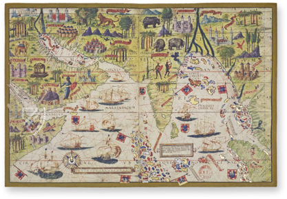
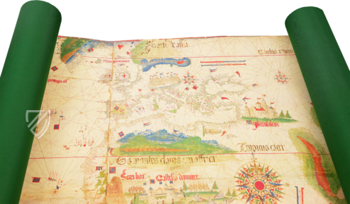
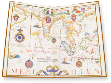
The Universal Atlas of Fernão Vaz Dourado arose in Portugal ca. 1571. Fernão Vaz Dourado is considered to be one of the most gifted cartographers of the Renaissance and his atlas contains some of the most artistically valuable and most modern geographic maps from Europe at that time. The maps were copied numerous times and served as a template for new and expanded maps.
Universal Atlas of Fernão Vaz Dourado
Portugal plays a special role in the history of cartography. Since the beginning of the 16th century, Portuguese explorers set out into every land and sea in the world and opened up virtually unknown regions. In the course of this pioneering work, Portugal developed probably the most important cartography school of the European Renaissance. Since the 16th century, some of the most important geographical charts arose here, which served as the cornerstone for our modern geography and navigation. Fernão Vaz Dourado, one of the most famous and esteemed cartographers of his time, recorded in his world atlas all of the geographic findings of his time and designed it in the most beautiful and artistically appealing manner.
Who was Fernão Vaz Dourado?
Fernão Vaz Dourado was a Portuguese cartographer, whose work is positioned in the last phase of handwritten cartography. His maps depicted continents and lands very realistically and in great detail, which is extremely impressive for a time without modern technical resources. Each of his individual large-format maps impresses through its unusual quality and beauty. Experts consider him to be probably the greatest cartographer of the Renaissance.
Geographic Templates
The Universal Atlas of Fernão Vaz Dourado was produced taking into account the most modern geographic facts and rules of its time of creation. Its maps serve not only as practical resources for the journey by land and water – they were absolute masterpieces of medieval book art. After the discovery of the book printing, the painting-like maps were reproduced in every region of Europe. New maps were made using them as a basis, which broadened the impressive findings. Originally, this world atlas consisted of 20 vellum maps. However, two of the maps were stolen in 1851 and remain missing to this day. The remainder of the 18 sheets of the valuable atlas are housed in the Arquivo Nacional da Torre do Tombo in Lisbon.
Codicology
- Alternative Titles
- Atlas universal de Fernão Vaz Dourado
Weltatlas des Fernao Vaz Dourado
Univeralatlas des Fernao Vaz Dourado
Atlas universel de Fernão Vaz Dourado
Atlante universale di Fernão Vaz Dourado - Type
- Map on parchment
- Size / Format
- Original atlas contained 20 parchment sheets. Folios 1 (frontispiece) and 8 (Eastern part of the Mediterranean) were stolen in 1851 from the atlas housed in Arquivo Nacional da Torre do Tombo, Lisbon. / 53.0 × 41.0 cm
- Origin
- Portugal
- Date
- 1571
- Epochs
- Style
- Genre
- Language
- Illustrations
- 18 maps
- Artist / School
- Fernão Vaz Dourado (1520–1580)
- Previous Owners
- Teotónio de Bragança
Charterhouse Santa Maria de Scala Coeli (Evora, Portugal)
Francisco da Costa
#1 Atlas universal de Fernão Vaz Dourado
Languages: Spanish, English
(3,000€ - 7,000€)
- Treatises / Secular Books
- Apocalypses / Beatus
- Astronomy / Astrology
- Bestiaries
- Bibles / Gospels
- Chronicles / History / Law
- Geography / Maps
- Saints' Lives
- Islam / Oriental
- Judaism / Hebrew
- Single Leaf Collections
- Leonardo da Vinci
- Literature / Poetry
- Liturgical Manuscripts
- Medicine / Botany / Alchemy
- Music
- Mythology / Prophecies
- Psalters
- Other Religious Books
- Games / Hunting
- Private Devotion Books
- Other Genres
- Afghanistan
- Armenia
- Austria
- Belgium
- Colombia
- Croatia
- Czech Republic
- Denmark
- Egypt
- Ethiopia
- France
- Germany
- Hungary
- India
- Iran
- Iraq
- Israel
- Italy
- Japan
- Luxembourg
- Mexico
- Morocco
- Netherlands
- Peru
- Poland
- Portugal
- Russia
- Serbia
- Spain
- Sri Lanka
- Sweden
- Switzerland
- Syria
- Turkey
- Ukraine
- United Kingdom
- United States
- Uzbekistan
- Aboca Museum
- Ajuntament de Valencia
- Akademie Verlag
- Akademische Druck- u. Verlagsanstalt (ADEVA)
- Aldo Ausilio Editore - Bottega d’Erasmo
- Alecto Historical Editions
- Alkuin Verlag
- Almqvist & Wiksell
- Amilcare Pizzi
- Andreas & Andreas Verlagsbuchhandlung
- Archa 90
- Archiv Verlag
- Archivi Edizioni
- Arnold Verlag
- ARS
- Ars Magna
- ArtCodex
- AyN Ediciones
- Azimuth Editions
- Badenia Verlag
- Bärenreiter-Verlag
- Belser Verlag
- Belser Verlag / WK Wertkontor
- Benziger Verlag
- Bernardinum Wydawnictwo
- BiblioGemma
- Biblioteca Apostolica Vaticana (Vaticanstadt, Vaticanstadt)
- Bibliotheca Palatina Faksimile Verlag
- Bibliotheca Rara
- Boydell & Brewer
- Bramante Edizioni
- Brepols Publishers
- British Library
- C. Weckesser
- Caixa Catalunya
- Canesi
- CAPSA, Ars Scriptoria
- Caratzas Brothers, Publishers
- Carus Verlag
- Circulo Cientifico
- Club Bibliófilo Versol
- Club du Livre
- CM Editores
- Collegium Graphicum
- Collezione Apocrifa Da Vinci
- Comissão Nacional para as Comemorações dos Descobrimentos Portugueses
- Coron Verlag
- Corvina
- CTHS
- D. S. Brewer
- De Agostini/UTET
- De Schutter
- Deuschle & Stemmle
- Deutscher Verlag für Kunstwissenschaft
- DIAMM
- Droz
- E. Schreiber Graphische Kunstanstalten
- Ediciones Boreal
- Ediciones Grial
- Ediclube
- Edições Inapa
- Edilan
- Editalia
- Edition Georg Popp
- Edition Leipzig
- Edition Libri Illustri
- Editiones Reales Sitios S. L.
- Éditions de l'Oiseau Lyre
- Editions Medicina Rara
- Editorial Casariego
- Editorial Mintzoa
- Editrice Antenore
- Editrice Velar
- Edizioni Edison
- Egeria, S.L.
- Eikon Editores
- Electa
- Enciclopèdia Catalana
- Eos-Verlag
- Ephesus Publishing
- Eugrammia Press
- Extraordinary Editions
- Fackelverlag
- Facsimila Art & Edition
- Facsimile Editions Ltd.
- Facsimilia Art & Edition Ebert KG
- Faksimile Verlag
- Feuermann Verlag
- Folger Shakespeare Library
- Franco Cosimo Panini Editore
- Friedrich Wittig Verlag
- Fundación Hullera Vasco-Leonesa
- G. Braziller
- Gabriele Mazzotta Editore
- Gebr. Mann Verlag
- Gesellschaft für graphische Industrie
- Getty Research Institute
- Giovanni Domenico de Rossi
- Giunti Editore
- Graffiti
- Grafica European Center of Fine Arts
- Guido Pressler
- Guillermo Blazquez
- H. N. Abrams
- Harrassowitz
- Helikon
- Hendrickson Publishers
- Henning Oppermann
- Herder Verlag
- Hes & De Graaf Publishers
- Hoepli
- Hortus Deliciarum
- Houghton Library
- Hugo Schmidt Verlag
- Idion Verlag
- Il Bulino, edizioni d'arte
- ILte
- Imago
- Insel Verlag
- Instituto de Estudios Altoaragoneses
- Instituto Nacional de Antropología e Historia
- Istituto dell'Enciclopedia Italiana - Treccani
- Istituto Ellenico di Studi Bizantini e Postbizantini
- Istituto Geografico De Agostini
- Istituto Poligrafico e Zecca dello Stato
- Italarte Art Establishments
- J. Thorbecke
- Jan Thorbecke Verlag
- Johnson Reprint Corporation
- Jugoslavija
- Karl W. Hiersemann
- Kasper Straube
- Kaydeda Ediciones
- Konrad Kölbl Verlag
- Kurt Wolff Verlag
- La Liberia dello Stato
- La Linea Editrice
- La Meta Editore
- Lambert Schneider
- Landeskreditbank Baden-Württemberg
- Leo S. Olschki
- Les Incunables
- Library of Congress
- Libreria Musicale Italiana
- Lichtdruck
- Lito Immagine Editore
- Lumen Artis
- Lund Humphries
- M. Moleiro Editor
- Maison des Sciences de l'homme et de la société de Poitiers
- Manuscriptum
- Maruzen-Yushodo Co. Ltd.
- MASA
- McGraw-Hill
- Militos
- Millennium Liber
- Müller & Schindler
- National Library of Wales
- Neri Pozza
- Nova Charta
- Oceanum Verlag
- Odeon
- Orbis Mediaevalis
- Orbis Pictus
- Österreichische Staatsdruckerei
- Oxford University Press
- Pageant Books
- Parzellers Buchverlag
- Patrimonio Ediciones
- Pattloch Verlag
- PIAF
- Pieper Verlag
- Plon-Nourrit et cie
- Prestel Verlag
- Princeton University Press
- Prisma Verlag
- Priuli & Verlucca, editori
- Pro Sport Verlag
- Propyläen Verlag
- Pytheas Books
- Quaternio Verlag Luzern
- Reales Sitios
- Recht-Verlag
- Reichert Verlag
- Reichsdruckerei
- Riehn & Reusch
- Roberto Vattori Editore
- Rosenkilde and Bagger
- Roxburghe Club
- Salerno Editrice
- Sarajevo Svjetlost
- Schöck ArtPrint Kft.
- Scolar Press
- Scrinium
- Scripta Maneant
- Scriptorium
- Siloé, arte y bibliofilia
- SISMEL - Edizioni del Galluzzo
- Sociedad Mexicana de Antropología
- Sorli Ediciones
- Stainer and Bell
- Styria Verlag
- Sumptibus Pragopress
- Szegedi Tudomànyegyetem
- Taberna Libraria
- Tarshish Books
- Taschen
- Tempus Libri
- Testimonio Compañía Editorial
- Thames and Hudson
- The Clear Vue Publishing Partnership Limited
- The Facsimile Codex
- The Folio Society
- The Marquess of Normanby
- The Richard III and Yorkist History Trust
- Tip.Le.Co
- TouchArt
- TREC Publishing House
- TRI Publishing Co.
- Trident Editore
- Typis Regiae Officinae Polygraphicae
- Universidad de Granada
- University of California Press
- University of Chicago Press
- Urs Graf
- Vallecchi
- Van Wijnen
- VCH, Acta Humaniora
- VDI Verlag
- Verlag für Regionalgeschichte
- Verlag Styria
- Vicent Garcia Editores
- W. Turnowsky
- Wiener Mechitharisten-Congregation (Wien, Österreich)
- Wissenschaftliche Buchgesellschaft
- Xuntanza Editorial
- Zollikofer AG


